The Extent of the Outwood
The Outwood covered most of the northern part of what was then Stanley township and part of the adjoining township of Alverthorpe. More particularly, we can be fairly sure that the northern and western boundaries of the Outwood, adjacent to Lofthouse and Ardsley, have remained intact since the 14th century.
These survived to recent times as parish, national and EU constituency boundaries and in part follow natural features such as Balne Beck or its tributaries and Lingwell Gate Beck which can be seen today.
The southern boundaries are now much harder to discern on the ground, being confused by subsequent settlements and new roads.
Boundaries of the Outwood
In medieval times, the boundary of the Outwood was marked by physical barriers which were integral to the administration and management of the area, in some places this was evidently a ditch and bank with a hedge, in other places, it consisted of a fence of wooden stakes or iron railings fixed in the ground, forming an enclosure.
Maintaining the boundaries and policing the manorial regulations which governed the Outwood was taken care of by annually elected Foresters, offenders were brought before the Wakefield Manor Court.
Roads and Gates in to the Outwood
Various roads crossed the Outwood and these were the only legal ways through the area, The Outwood had barriers or gates to restrict access to permitted times, both for people and for animals, these gates also controlled stock, some which needed to be kept within the woodland, and some which had to be excluded.
The localities of some of the medieval entrances to the Outwood survive in present day place names, such as Kirkhamgate, Carr Gate, Lingwell Gate and Lofthouse Gate.
Manorial Laws in the Outwood
Apart from prosecutions for damaging or failing to repair the boundary barriers and gates to the Outwood and trespass of animals and people, the Manor Court Rolls preserve records of various other kinds of offence against the Outwood regulations, which included the illicit felling of trees.
For example, marking trees for felling by cutting a landlord's mark was a custom within the Manor of Wake field so individuals counterfeiting this were fined and other offences included stealing cut timber, collecting underwood and cutting branches out of season, illicit collecting of acorns, ploughing, bringing tools illegally into the Outwood and carrying out an unlicensed trade.
Records of various transgressions and family names suggest that, in and around the Outwood, there were trades such as wood-turning, board-making for tables and fences, coopering or barrel-making, bark-stripping and tanning.
Farming in the Outwood
All the evidence points to a landscape which was in active use and which was probably not, even in medieval times, completely wooded. Indeed, clearance for ploughing may have begun towards the end of the 13th century and, by the 15th century.
The Outwood was probably a mixed landscape of trees and open ground with lot’s of human activity within it, both licensed and unlicensed.
There are frequent records of animals straying in the Outwood and causing damage and when rounded up, such stock are known to have been put into pounds run by an official called a Pinder hence the local Pinders Fields or Pinderfields* on the slopes between the Outwood and the river Calder.
The Manor Court Rolls also reveal that it was the practice to bring hay into the Outwood as winter fodder and this may have required barns within the boundary for storage. There was also a right of pannage within the Outwood allowing pigs to feed on acorns dropped from the oaks..
* from where our local hospital acquired it’s name
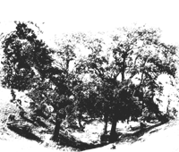
Trees in the Outwood
Although it is possible to predict from the local geology and soils what the general character of the woodland canopy would have been in the Outwood, the Manor Court Rolls provide glimpses of many actual species of trees and shrubs which were the subject of licence and litigation locally, for example, there are references to oak, elm, alder, ash, birch, hawthorn, holly, hazel and maple. the last is especially interesting because, these would be the first documentary records of this tree being introduced in to Britain.
The end of the Outwood
In the eras following the medieval period, the Outwood figures in various kinds of documentary records which again illuminate its complicated history.
In the Wakefield Manor Book of 1709, for example, there, is a list of cottage rents showing that many individuals by then had small dwellings, and crofts within the Outwood.
Its open common character came to an end with the enclosure of all the Wakefield common lands in 1793 In that year, an Act of Parliament divided into private fields what had previously been common, village greens, arable strip fields and water meadows.
Shortly after enclosure, the Lake Lock Rail Road, with horse drawn wagons pulled on iron edge rails was constructed from the Outwood coal pits down to the river Calder. This Nagger Line as it became known locally was the first railway in the world to be financed using the capital of shareholders maintaining the line for both coal and fare paying passengers..